

The United Kingdom is bracing for the arrival of Storm Floris, a powerful weather system named by the Met Office that is set to hit the country on Monday. This marks the sixth named storm of the season and the first to appear since January, signaling a significant return to stormy conditions as summer begins to wind down.
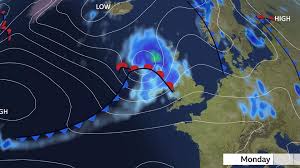
According to meteorologists, Storm Floris will bring strong winds, heavy rain, and the potential for widespread disruption across northern and western parts of the UK. The storm is forecasted to take a track across the northern half of the UK, with the most intense winds expected on the southern and western flanks of the system.
Table of Contents
What to Expect from Storm Floris
Storm Floris is expected to develop from a low-pressure system that was initially observed over the Great Lakes region in the United States. As this system moves into the Atlantic Ocean, it will be picked up by a powerful jet stream, rapidly intensifying as it approaches the UK.
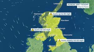
This intense drop in atmospheric pressure is a classic sign of storm development and will likely lead to wind gusts ranging from 60 to 70 mph, especially in coastal and hilly areas in northern parts of the country. Some parts of Scotland’s exposed coastal regions could see gusts as high as 85 mph.
Even inland regions aren’t likely to escape the impact of Storm Floris. Forecasts suggest gusts of 40-50 mph in many areas, while even southern England may see gusts approaching 45 mph.
Weather Warnings Issued
In anticipation of the incoming storm, the Met Office has issued a yellow wind warning for the northern half of the UK. The warning will be in effect from 6:00 AM on Monday to 6:00 AM on Tuesday. Residents are being urged to prepare for travel disruptions, potential damage to structures, and the risk of falling branches and trees.
Since Storm Floris is arriving during summer, the impacts could be even more severe than if the same storm had occurred in winter. Trees are in full leaf during this time of year, which makes them more vulnerable to being uprooted by strong winds. Additionally, many temporary summer structures—such as festival tents, marquees, and outdoor stages—could be damaged or destroyed by the forceful gusts.
A Growing Concern for Travel and Infrastructure
The strong winds from Storm Floris are likely to affect transportation networks across the UK. Roads, railways, and ferry services could face delays and cancellations. High-sided vehicles may be especially vulnerable on bridges and open roads, where crosswinds will be strongest.
In addition to wind, Storm Floris will also bring heavy rainfall, which could lead to localized flooding in certain areas. With the ground already saturated in some regions following a wet July, it won’t take much for streams and rivers to overflow their banks. Commuters and travelers are advised to monitor weather updates closely and plan accordingly.
Power disruptions are another major concern, particularly in rural and coastal areas. The combination of strong winds and wet conditions often leads to fallen power lines and outages.
Summer Storms: A Rare But Not Unprecedented Event
While storms of this magnitude are typically associated with autumn or winter, Storm Floris is a reminder that summer storms, though less frequent, can still occur—and when they do, the consequences can be severe.
August named storms are not unheard of in the UK. In recent years, several significant summer storms have made headlines:
- In August 2024, Storm Lilian impacted the UK just before the bank holiday weekend, resulting in event cancellations such as the Leeds Festival and disruptions at Heathrow Airport.
- In 2023, Storm Antoni brought high winds and heavy rainfall to south Wales and south-west England, affecting large-scale events including Brighton and Plymouth Pride.
- Just weeks later, Storm Betty followed with even more disruption.
- Back in 2020, two significant August storms, Ellen and Francis, swept through the UK. With wind gusts recorded at 79 mph and 81 mph, both storms caused major transport disruptions, flooding, and widespread power cuts.
So while Storm Floris may be arriving in a month typically associated with sunshine and calm, it is not without precedent.

Unusual Weather Patterns and a Warming Climate
July 2025 has already proven to be a month of contrasts. According to provisional data from the Met Office, it was the UK’s fifth warmest July on record. Each of the four nations experienced unusually high temperatures:
- Scotland and Northern Ireland had their sixth warmest Julys.
- England recorded its seventh warmest July.
- Wales experienced its tenth warmest.
The highest temperature of the year so far—35.8°C—was recorded on July 1st in Faversham, Kent. This warm spell was accompanied by uneven rainfall patterns. While Kent saw 86% more rainfall than average, Dorset recorded just half its normal rainfall.
This variability, coupled with the arrival of Storm Floris, points to a broader trend linked to climate change. Experts warn that as the climate warms, the UK will see milder, wetter winters and hotter, drier summers. However, such summers will occasionally be interrupted by intense and unseasonal storms like Storm Floris.
Additionally, a significant marine heatwave around the UK continues, with sea surface temperatures 1.5°C to 2°C above average. Warmer seas can add energy and moisture to developing weather systems, fueling stronger storms.
Preparing for Storm Floris
With just days remaining before Storm Floris makes landfall, residents, travelers, and local authorities are being urged to take precautionary measures.
Safety Tips:
- Secure loose items: Garden furniture, tents, and other outdoor items should be tied down or brought indoors.
- Avoid coastal areas: Strong winds and large waves pose a risk near shorelines.
- Plan travel in advance: Expect delays or cancellations and keep an eye on transport updates.
- Stay informed: Monitor Met Office warnings and local weather forecasts regularly.
- Charge electronics: In case of power outages, make sure mobile devices and batteries are fully charged.
- Check on vulnerable individuals: Elderly neighbors or those living alone may need extra support.
Event Organizers on High Alert
Several summer events scheduled for the coming week may face cancellations or postponements due to Storm Floris. Outdoor concerts, local fairs, and sporting events are particularly vulnerable.
Organizers are monitoring forecasts closely and will update attendees as more information becomes available. In many cases, insurance policies for such events include storm clauses, and Storm Floris may trigger compensation claims.
Could Storm Floris Shift?
Meteorologists caution that the track of Storm Floris is still subject to change. Small shifts in the storm’s path could alter which regions are worst hit. However, the general consensus among forecasters is that the storm will bring widespread impacts, particularly to Scotland, Northern Ireland, and northern England.
The public is encouraged to remain vigilant and check updates over the weekend as new data emerges.
The Broader Implication of Storm Floris
Beyond the immediate weather disruption, Storm Floris is part of a growing trend in the UK’s evolving climate. Increased frequency and intensity of extreme weather events—even during months that were traditionally calmer—are becoming more common.
Scientists warn that as sea levels rise, sea temperatures warm, and the jet stream becomes more erratic, the UK will experience more volatile weather patterns, including storms like Floris during the summer months.
This raises new challenges for infrastructure, agriculture, energy grids, and emergency services, which must adapt to a climate that no longer follows predictable seasonal patterns.
Final Thoughts: What Storm Floris Tells Us
The arrival of Storm Floris may seem like an unusual disruption in the midst of summer, but it is also a powerful reminder of how dynamic and unpredictable our weather can be. From strong winds and heavy rain to potential flooding and travel chaos, Storm Floris carries the potential for serious consequences if not taken seriously.
As we prepare for Monday’s incoming storm, the key takeaway is to stay alert, stay safe, and stay informed. With changing climate patterns and increasingly active storm seasons, events like Storm Floris may become more common in the years ahead.